
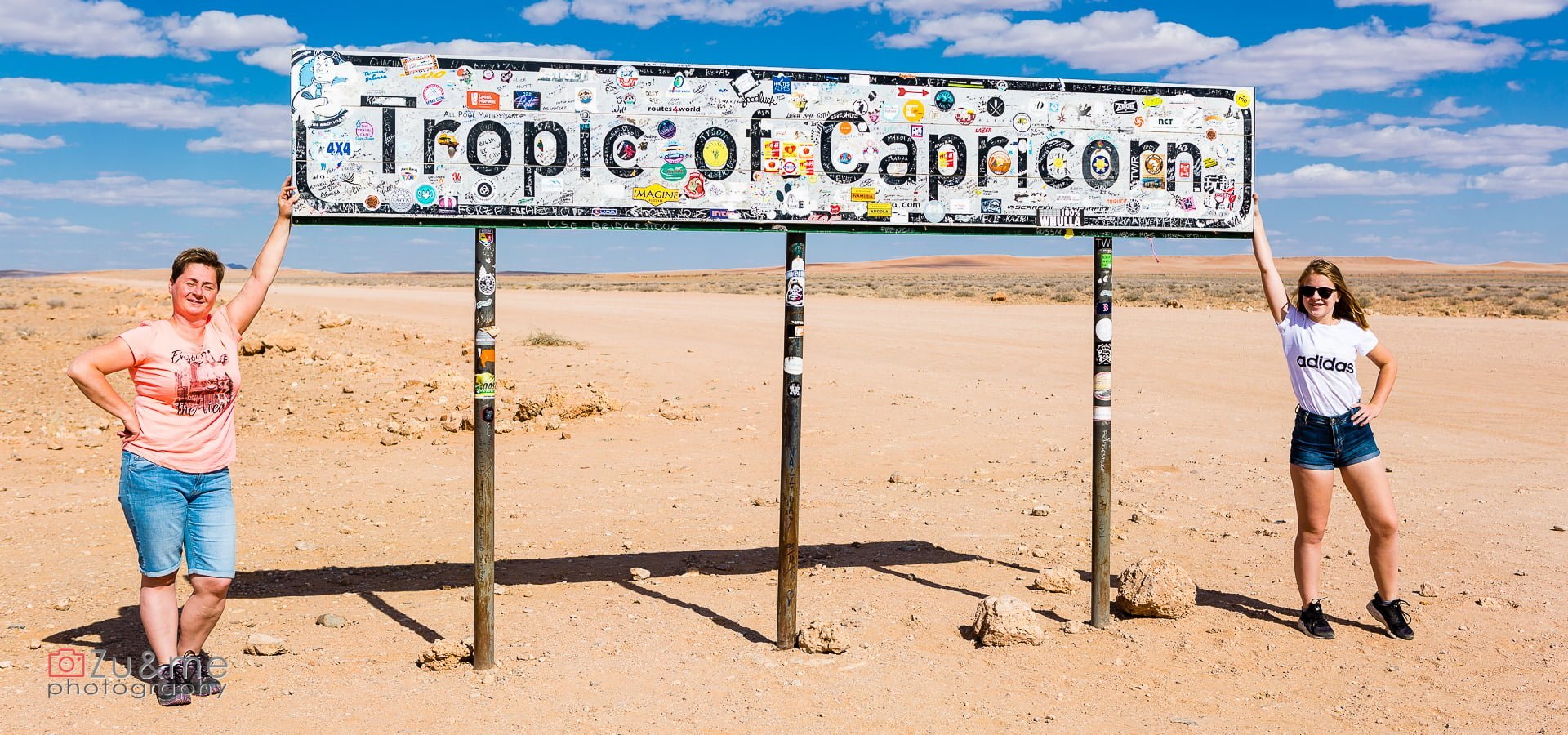
Zwrotnik Koziorożca, Walvis Bay i Swakopmund (dzień 7)
14 sierpnia 2018
W wiosce Damara (dzień 9)
23 sierpnia 2018
Najpierw kierujemy się w stronę Cape Cross, aby odwiedzić kolonię fok. Jedziemy drogą wzdłuż wybrzeża i nie wiemy dlaczego, ale liczyliśmy na śliczną pogodę 😊 Tymczasem wieje. I to wieje tak, jak jeszcze do tej pory nie wiało. Dodatkowo wiatr wieje nie od wody, ale od lądu. Trudno ustać, a na każdej odsłoniętej części ciała czuć igiełki gruboziarnistego piasku, bombardującego ciało z nieziemską siłą.

Wybrzeże szkieletów
Jedziemy wzdłuż Wybrzeża Szkieletów. Brzeg ten zwany przez żeglarzy bramą piekieł, pokonał wiele statków. A dla tych, którzy pomyślnie wylądowali, ze względu na silne prądy stawał się więzieniem. Podobno nie sposób odbić od brzegu opierając się jedynie na sile mięśni ludzkich.Zjeżdżamy z drogi w stronę plaży, aby rozejrzeć się za reklamowanymi w przewodnikach wrakami. Niestety, wiatr nie jest sprzymierzeńcem zwiedzania – jakby nie ustawić auta, to albo nie da się otworzyć drzwi pod naporem wiatru, albo nie da się ich zamknąć, bo są wyrywane, a w każdym przypadku miliony ziaren piasku przewala się przez szoferkę. Asia wychodzi i czym prędzej (z trudem) wraca – ma krótkie spodenki, a jej łydki w chwilę stają się czerwone. Ja muszę mieć zdjęcia. Mam długie spodnie, naciągam polara i czapkę i ruszam po fotorelację. Kurde – ale wieje! Fale ledwo co są w stanie pokonać siłę wiatru – są zwiewane w kierunku oceanu. Widać walkę żywiołów. Lokalizuję największy z wraków, strzelam kilka fotek i już mam dość. Jak tu wrócić pod wiatr? Naciągam czapkę na oczy, aparat chowam za swoim ciałem i z trudem, trochę po omacku, wracam do auta. Ze zwiedzania plaży i poszukiwania wraków oraz szkieletów wychodzą nici. Ten upolowany to trawler Zeila, który zatonął w 2008 roku. Jedziemy dalej asfaltówką, która ma biały kolor od pokrywającej ją soli. Ponoć po deszczu na soli jest ślisko jak na lodzie – na szczęście nie musimy tego sprawdzać na własnej skórze.


Cape Cross – odwiedziny u fok
Tak naprawdę to punktem kulminacyjnym dzisiejszego dnia są foki. Uchatki obrały sobie wybrzeże Namibii jako swoją bazę i tu żyją, w koloniach sięgających wielu tysięcy osobników. Rezerwat to jedna z największych kolonii na wybrzeżu. Podjeżdżamy szczęśliwi, że na parkingu jest tylko jedno auto i będziemy mogli celebrować to spotkanie niemal w samotności. Nawet wiatr jakby lekko zelżał. Pierwsza wyskakuje Asia i jeszcze szybciej wraca do auta. Właściwie to nie zdążyła nawet wysiąść, a dopadł ją zapach fok. Odór jest niesamowity. Ciężki, wyrazisty i przeszywający do szpiku kości 😊 Sama esencja smrodu. Nic to, po to tu przyjechaliśmy, aby się zmierzyć z tym wyzwaniem. Trochę żałujemy, że nie wieje tak mocno jak przy wraku (żart). Trochę narzekamy, próbujemy zatykać nozdrza, ale po chwili sami już tak śmierdzimy, że woń uchatek nie robi na nas wrażenia. Możemy się za to skupić na zwierzakach. Są super.


Cape Cross
Cape Cross
Cape Cross (Afrikaans: Kaap Kruis; German: Kreuzkap; Portuguese: Cabo da Cruz) is a headland in the South Atlantic in Skeleton Coast, western Namibia.[1]
History

In 1484, Portuguese navigator and explorer Diogo Cão was ordered by King John II of Portugal to advance south into undiscovered regions along the west coast of Africa, as part of the search for a sea route to India and the Spice Islands. While doing so, he was to choose some particularly salient points and claim them for Portugal by erecting stone crosses called padrões. During his first voyage, thought to have taken place in 1482, he reached a place he called Monte Negro, now called Cabo de Santa Maria, roughly 150 km southwest of today's Benguela, Angola.
During his second voyage, in 1484–1486, Cão reached Cape Cross in January 1486, being the first European to visit this area. He is known to have erected two padrões in the areas beyond his first voyage, one in Monte Negro, and the second at Cape Cross. The current name of the place is derived from this padrão. What can today be found at Cape Cross are two replicas of that first cross.[2]
Padrão

The original Cape Cross padrão was removed in 1893 by Corvette captain Gottlieb Becker, commander of the unprotected cruiser SMS Falke of the German Navy, and taken to Berlin. The cross is now held in the Deutsches Historisches Museum. A simple wooden cross was put in its place. The wooden cross was replaced two years later by a stone replica.
At the end of the 20th century, thanks to private donations, another cross, more similar to the original one, was erected at the cape along with the first replica. The inscription on the padrão reads, in English translation:[3]
In the year 6685 after the creation of the world and 1485 after the birth of Christ, the brilliant, far-sighted King John II of Portugal ordered Diogo Cão, knight of his court, to discover this land and to erect this padrão here".
Seal reserve

Cape Cross is a protected area proclaimed in the early 1960s.[4] Today it owned by the government of Namibia under the name Cape Cross Seal Reserve. The reserve is the home of one of the largest colonies of Cape fur seals in the world.[5]
Cape Cross is one of two main sites in Namibia (the other is in Lüderitz) where seals are culled, partly for selling their hides and partly for protecting the fish stock. The economic impact of seals on the fish resources is controversial: while a government-initiated study found that seal colonies consume more fish than the entire fishing industry can catch,[6] animal protection society Seal Alert South Africa estimated less than 0.3% losses to commercial fisheries.[7]
References
- ^ "Cape Cross". capecross.org. Archived from the original on 9 June 2018. Retrieved 30 May 2010.
- ^ "Diogo Cão" Archived 20 March 2012 at the Wayback Machine, Encyclopædia Britannica
- ^ "Henties Bay to Palmwag". fuzzytravel.com. Archived from the original on 12 April 2011. Retrieved 26 September 2012.
- ^ Goldbeck, Manfred (15 August 2025). "70 years of Nature Conservation". The Namibian (Reprint). p. 13.
- ^ "Cape Cross". namibian.org. Archived from the original on 11 February 2010. Retrieved 30 May 2010.
- ^ Weidlich, Brigitte (28 June 2007). "Seal quota down for this season". The Namibian. Archived from the original on 7 June 2011. Retrieved 30 June 2011.
- ^ "Time for Namibia to see the tourism value of seals". The Namibian. 17 June 2010. Archived from the original on 17 March 2012.
External links
Spitzkoppe


Spitzkoppe


The Spitzkoppe (from German for "pointed dome"; also referred to as Spitzkop, Groot Spitzkop, or the "Matterhorn of Namibia") is a group of bald granite peaks or inselbergs located between Usakos and Swakopmund in the Namib desert of Namibia. The granite is more than 120 million years old and the highest outcrop rises about 1,728 metres (5,669 ft) above sea level. The peaks stand out dramatically from the flat surrounding plains. The highest peak is about 670 m (2,200 ft) above the floor of the desert below. A minor peak – the Little Spitzkoppe – lies nearby at an elevation of 1,557 m (5,108 ft). Other prominences stretch out into a range known as the Pontok Mountains.[1]
Many examples of Bushmen artwork can be seen painted on the rock in the Spitzkoppe area. Photographs of the Spitzkoppe Mountains were used as backgrounds for 2001: A Space Odyssey in the "Dawn of Man" sequences.[2][3]
History of ascent
Any ascent of the peak involves exposed and delicate rock climbing of a high grade. While the standard route up the peak is not severely difficult in modern technical terms, it presented quite a formidable undertaking in the earliest days, owing to the isolation of the peak, the heat of the desert and the total lack of water.
Before the First World War what is now Namibia was German South-West Africa. It is possible that the main peak was reached as early as 1904, when a soldier of the Imperial Schutztruppe supposedly soloed the peak and made a fire on the summit. What he may have burned remains a mystery, as there is no natural fuel of any kind on the upper parts of the peak. The legend suggests that he never returned and that his body was never recovered. Certainly, no proof of his conquest is available today. The first documented conquest was made by a team of climbers from Cape Town, led by S. le Roux. The next party – O'Neil, Shipley and Schaff – pioneered a route up the northern extremes of the peak, after having failed on the southwest ridge. They gained access to the gully now known as the "scramble" but ran out of time to attempt the final faces. Four days later they made another attempt but finally gave up. Some of the earliest climbers, defeated by an extraordinarily smooth band of granite only about 3m high, resorted to carving steps into the rock with a hammer and chisel.
A few months later Hans and Else Wong and Jannie de Villiers Graaff arrived and they reached the summit at noon, in November 1946. For the next quarter of a century the mountain maintained its reputation of presenting a two- or three-day struggle to potential climbers. (There are accounts of these ascents in old volumes of the Journal of The Mountain Club of South Africa – one of which can be found at scanned extracts from MCSA Journal.)
This era came to an end in 1971, when the peak was climbed in four hours by a party led by J. W. Marchant from the University of Cape Town Mountain and Ski Club. Included were the talented South African climber Gabriel Athiros and Oliver Stansfield from England [2 June 1971]. This team scaled all of the lower pitches without ropes and got through the difficult band without using the artificial steps hacked into the granite. They descended from the peak in two hours and as they reached the base rain began to fall for the first time in over a year.

The modern era commenced. E. Haber, together with A. Lombard, C. Ward and Holding completed the first direct ascent of the South West Wall. They began their endeavours in 1977 but did not succeed in finishing the route before 1982. M. Cartwright and M. Hislop freed the route in 1988, giving it a grade of 22, which was later revised to 24. C. Edelstein and G. Mallory left their mark in 1983 by completing "Royale Flush", another monster route that was freed only in 2000 by J. Wamsteker and S. Wallis. During 1991 M. Cartwright, K. Smith and M. Seegers put up a difficult route named INXS graded 24 left of the South West Wall route.
General development and history


In 1896, a trading post named Spitzkopje was built below the mountain by the German Colonial Society, the centrepiece of a 120,000-hectare farm. The Society built a five-room farmhouse and stables, storerooms and other outbuildings. In 1899 the farm held 120 horses, 1,500 cattle and 4,000 sheep and goats; its manager was a German settler named Carl Schlettwein.[4] Later it was transferred to the Farmer Jooste and a police station was built (the foundation walls are still under Pontok 4 chroma noise).[clarification needed]
In 1964, under the "Odendaal Plan" of the Odendaal Commission for the creation of home territories (home lands) for the black population, the farm was expropriated with compensation. In 1970 they moved multiple Damara families here, which were in fact a village with a church and school development. Since 1998, the municipal campsite and the area was declared as Gaingu Conservancy on 7 September 2003 around the Great Spitzkoppe. A Hollywood film company[who?] erected a high game fence which cuts off the entire area between the large Spitzkoppe and Spitzkoppe Pontoks. This represents about half of the camping places which ceased to exist, access to many climbing rocks and also the normal route to the Great Spitzkoppe barred. The popular Circumnavigation of the Great Spitzkoppe (1–1.5 hours) is no longer possible.
"Bushman Paradise" made accessible through a gate with chains, has lost its attractiveness, as almost all of the 2000- to 4000-year-old prehistoric rock paintings have been destroyed. Around the foot of the Great Spitzkoppe you can still find good[according to whom?] drawings, especially at the "Rhino Rock". The site has a population of community members who over the years started living and grazing their livestock in the area. It has leadership of a headman, vice headman and councillors.
References
- ^ "Spitzkoppe Namibia". Namibia-1on1.com. Retrieved 27 September 2016.
- ^ Chiasson, Dan (16 April 2018). ""2001: A Space Odyssey": What It Means, and How It Was Made". The New Yorker. Archived from the original on 26 October 2022.
- ^ ""2001: A Space Odyssey": Locations". Movie-Locations.com. Retrieved 25 July 2023.
- ^ Mansfeld, E. (2017). A German Settler's Life in Colonial Namibia. London: Jeppestown Press. pp. 17–25. ISBN 978-0-9570837-5-2.
External links
 Spitzkoppe travel guide from Wikivoyage
- Travellers Voice Magazine Spitzkoppe: Namibia's Rocky Eden
- Klettergebiet Spitzkoppe in Namibia
Zgubiona droga – offroad na azymut
- Ej nawigacja każe mi skręcić ostro w lewo, do wioski. Mam tam jechać?- Skąd mamy to wiedzieć, jesteśmy tu pierwszy raz.
- To odpalcie swoje nawigacje i sprawdźcie na mapie.
- Na mapie ten obszar zajmuje 3mm2… Co nam da opalenie 4 tych samych nawigacji?!
- Mam tam jechać?
- Skoro pokazuje to jedź…
Mniej więcej w ten sposób, choć w trochę większych emocjach, wpakowaliśmy się do wioski. Maps.me pokazało, że tędy trzeba jechać. Upewniliśmy się dwa razy, że to nie błąd ‘telefonu’ i pojechaliśmy zwiedzać lokalne zabudowania. Droga prowadziła pomiędzy domami, potem tuż przy płocie szkoły. Z tyłu głowy rodziło się przeczucie, że to nie jest właściwa droga, a w sercu kiełkowała chęć poznania i przygody. Największy problem zaczął się wtedy, gdy droga jasno zarysowana koleinami, zaczęła zmieniać się w ledwo widoczne esy-floresy, znaczone kołami aut, które jechały tędy raptem kilka razy. Navi nie miała większości odnóg, a my przy wyborze kierowaliśmy się intuicją i faktem największego rozjeżdżenia. Po drodze przekroczyliśmy kilka rzeczek z czego jedna to z pewnością była Spitzkopp river – przydała się wiedza z jazdy po wydmach – dzięki niej nie ugrzęźliśmy w piachu. Droga zamieniła się w dróżkę przedzierającą się pomiędzy krzakami. Odgłos ocierających się o auto kolców akacji przyprawiał o ciarki (a wyobraźnia podsuwała obraz porysowanego do gołego metalu lakieru). Zaliczyliśmy odcinek wąskiego nasypu (jakby kolejowego) i wjechaliśmy do jakiejś opuszczonej osady. Nie jest źle – są ludzie to znaczy, że będą drogi, a może przy okazji kogoś zapytamy. Najpierw wpakowaliśmy się na jakieś duże ogrodzone podwórko… Dookoła był płot, i nigdzie nie było żywego ducha. Kolejna droga zawiodła nas pomiędzy opuszczone domostwa (chyba opuszczone – wyglądało jakby ktoś tam mieszkał, ale nigdzie nikogo nie było). Przeciskamy się pomiędzy domem, a zbiornikiem na wodę. Tak prowadzi droga, a auto ledwo wchodzi z lusterkami (że nam to nie dało do myślenia). Przemy naprzód opuszczając osadę. Nawigacja za bardzo nie wie gdzie jesteśmy… ani tym bardziej nie umie pokazać nam, gdzie mamy dalej jechać. Kolejne rozwidlenia i kolejne decyzje w którą stronę jechać.
Powoli się rozglądamy, czy będzie w razie czego gdzie się zatrzymać, aby rozbić obóz. W pewnym momencie udaje się złapać sieć… jest „E” (czyli tyle co nic internetu…) Odpalamy Google maps próbując się zlokalizować. Mapy od googla nie znają naszych ścieżek, ale za to potrafią wskazać kierunek do drogi głównej. Posługując się telefonem jak kompasem i wybierając ścieżki podobne do dróg (aby nie jechać całkiem off-road), kierujemy się w stronę drogi głównej (szutrowej). Mamy do niej około 5km. Straaasznie nam się ten dojazd dłuży… Z jednej strony słońce chyli się ku zachodowi, z drugiej strony chcielibyśmy jak najszybciej się „odnaleźć”, a z trzeciej ukształtowanie terenu oraz krzaki nie pozwalają jechać szybciej niż kilka, kilkanaście kilometrów na godzinę. Wizja spania pośrodku niczego jest bardzo, bardzo blisko…


Zapisz się na powiadomienia
Chcesz być powiadamiany o nowych wpisach? Dodaj swój adres email do listy wysyłkowej, a otrzymasz powiadomienie o każdym nowym wpisie. :-) Nie spamujemy, nie udostępniamy adresów, zawsze możesz się wypisać.


